El Niño May Ignite a Strong 2026 Eastern Pacific Hurricane Season, Raising Risks for Coastal California
El Niño is forecast to sharply increase activity in the 2026 Eastern Pacific hurricane season, with warmer sea surface temperatures and reduced wind shear likely driving above-average numbers of named storms, hurricanes, and major hurricanes beginning in May.
Key takeaways
- El Niño odds: Models place roughly a 61% chance of El Niño forming in May–July 2026 and about a 25% chance it becomes a strong “super El Niño” by fall — Fox Weather, Time.
- Eastern Pacific impact: Warmer sea surface temperatures and reduced local wind shear can fuel faster storm formation and increased rapid intensification risk — Fox Weather, YouTube.
- Projected counts: Regional forecasts suggest about 18–21 named storms, 9–11 hurricanes, and 4–5 major hurricanes in the Eastern Pacific for 2026 — Wikipedia.
Mechanism in the Eastern Pacific
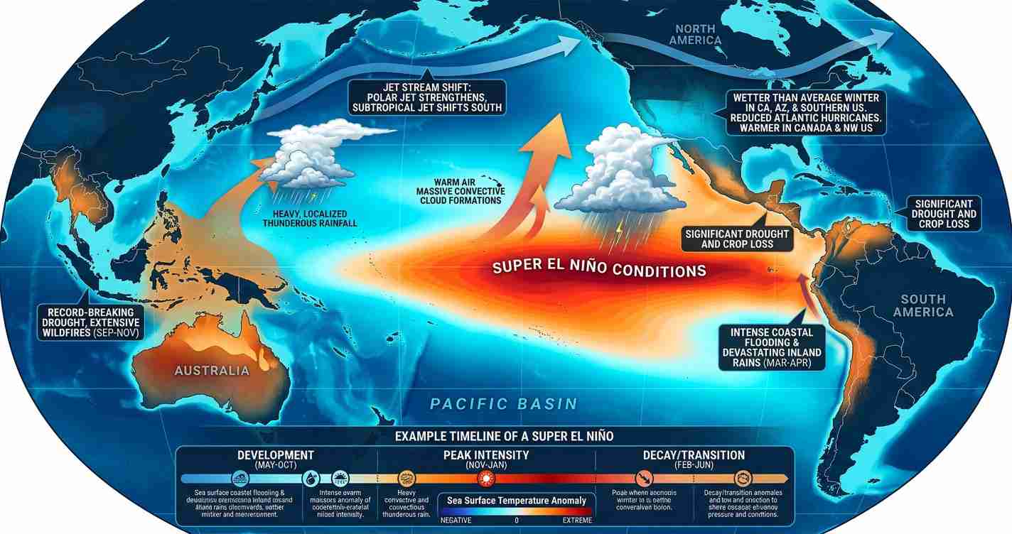
El Niño is a climate pattern in which the central and eastern tropical Pacific become warmer than normal. Those warmer waters alter atmospheric flow across the tropics: whereas El Niño often increases upper-level winds that shear apart developing storms in the Atlantic, in the Eastern Pacific the shift can boost convection and lower local wind shear, creating a more hospitable environment for tropical cyclones.
Warm sea surface temperatures (SSTs) provide the heat energy hurricanes need. When the ocean’s surface and subsurface are unusually warm, storms can draw more moisture and energy from the sea, accelerating growth and — under the right conditions — enabling rapid intensification similar to Hurricane Otis in 2023. Sources: Fox Weather, YouTube.
Why El Niño could ignite the season
Warmer SSTs: Monitoring shows Eastern Pacific SSTs running above average in places by about 1–3°C, increasing ocean heat content and the fuel available to storms. Analysts point to broader Pacific patterns such as the Pacific Decadal Oscillation that may amplify this warmth (video analysis, Wikipedia).
Reduced local wind shear: While El Niño often increases shear over the Atlantic, parts of the Eastern Pacific can experience lower shear during El Niño events, allowing storms to maintain structure and organize into hurricanes more easily (YouTube, Fox Weather).
Rapid intensification risk: Deep warm subsurface layers — not only surface warmth — can permit very fast strengthening. The surprise of Hurricane Otis in 2023 underscores how quickly conditions can change, reducing lead time for warnings and preparedness (Fox Weather).
Timing matters
The season’s character depends on when El Niño develops. If it forms early (before mid-summer), it can create favorable conditions for the entire season and increase the likelihood of more and stronger storms. If it strengthens later (after August), some Atlantic activity may occur first before the Pacific sees the full shift. Agencies and model ensembles are watching for early signals in spring and summer (Fox Weather, Time).
Forecast outlook and model signals
NOAA and other centers run many models to estimate El Niño odds and seasonal impacts. Current ensembles place about a 61% chance of El Niño in May–July 2026 and roughly a 25% chance of a strong “super El Niño” by fall — an outcome that would push Eastern Pacific temperatures higher and favor an above-average season (Fox Weather, Time).
Mexico’s forecasts and several regional ensembles are already suggesting higher counts for 2026 — estimates in the low 20s for named storms with multiple major hurricanes are being discussed, consistent with past moderate-to-strong El Niño years (Wikipedia, model synopses).
Historical context and what to watch
The Eastern Pacific season officially runs May 15–November 30 (Central Pacific: June 1–November 30), with peak activity July–October. Since 1990, moderate or stronger El Niño events have frequently coincided with above-average Eastern Pacific activity. Key indicators to watch this spring and summer include:
- Ocean temperature trends across the central and eastern tropical Pacific (Time, Fox Weather).
- Model ensemble guidance for El Niño strength and timing (NOAA-discussed ensembles summarized in media reports).
- Early-season tropical waves and Madden–Julian Oscillation pulses that can seed cyclone formation (YouTube analysis).
Implications for San Luis Obispo, California
Economic impact:
- Tourism and fisheries: More frequent or stronger Eastern Pacific storms can disrupt shipping, fishing, and seasonal tourism along the Central Coast. Heavy surf and coastal erosion could damage infrastructure supporting local businesses.
- Property and insurance: Increased storm surge and heavy rainfall risks may raise repair costs and affect insurance rates for coastal properties.
Political consequences:
- Local preparedness policy: City and county leaders may face pressure to update evacuation plans, emergency funding, and coastal management strategies as risk estimates change.
- State and federal coordination: San Luis Obispo will likely need closer coordination with California’s Office of Emergency Services and NOAA for early warnings and response support.
Social effects:
- Community safety: Rapidly intensifying storms can shorten warning times, increasing the need for outreach and clear communication, especially for vulnerable residents in low-lying areas.
- Displacement and services: Flooded roads and damaged housing could increase demand for shelters, healthcare, and nonprofit assistance.
Cultural relevance:
- Coastal lifestyle: Surfing, fishing, and beach access are central to local culture; larger swell events and more frequent impacts can alter shoreline use and perceptions of safety.
- Local conservation: Storm pattern changes may affect restoration and protection projects for coastal habitats important to community identity and recreation.
Practical applications — what residents can do now
- Review preparedness plans: Update family emergency plans, confirm evacuation routes, and note shelter locations.
- Home steps: Clear drains, secure loose outdoor items, check sump pumps, and consider backup power for flood-prone homes.
- Stay informed: Follow local emergency alerts, the National Weather Service, and official county communications during hurricane season. Reliable model updates and briefings include NOAA and reporting by outlets such as Fox Weather and coverage from Times Media Service.
Sources and further reading
- Fox Weather: “El Niño could boost hurricane activity in the Eastern Pacific in 2026”
- Time: “What to know about the potential super El Niño in 2026”
- Wikipedia: 2026 Pacific hurricane season (summary of regional forecasts and model output)
- Video analyses and expert discussions on seasonal drivers and El Niño impacts (YouTube)
- Additional video analysis of ocean heat content and seasonal drivers (YouTube)
Reporting by Times Media Service